Mapping Australian wildlife with the help of drones, AI and citizen scientists
In Australia, a groundbreaking project is underway that is using drones, artificial intelligence (AI), and citizen scientists to map the distribution and abundance of native wildlife.
The project is called Wildlife Drones, and it’s being led by researchers from the University of Adelaide. The goal of the project is to use drones equipped with AI software to survey and map wildlife populations, with the help of volunteer citizen scientists.
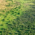
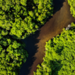
Using drones for wildlife surveys offers several advantages over traditional survey methods. Drones can cover large areas quickly and efficiently, and they can also reach remote or difficult-to-access areas. Additionally, the use of AI software can help to identify individual animals and track their movements over time.
To gather data, the Wildlife Drones team is using a combination of visual and thermal imaging. The thermal imaging technology can detect the body heat of animals, making it easier to spot them in dense vegetation or at night.
The data collected by the drones is then analyzed using AI software that can automatically identify and classify different species of animals. This technology is still in its early stages, but it has the potential to revolutionize the way wildlife surveys are conducted.
One of the most exciting aspects of the Wildlife Drones project is the involvement of citizen scientists. Anyone can participate in the project by downloading the Wildlife Drones app and using it to record wildlife sightings in their area. The app uses GPS technology to record the location of sightings, and this information is then used to build a database of wildlife distribution and abundance.
The involvement of citizen scientists is not only a valuable source of data for the project, but it also helps to raise awareness of the importance of wildlife conservation. By engaging people in the project, the Wildlife Drones team hopes to inspire a greater appreciation and understanding of Australia’s unique and diverse wildlife.
In conclusion, the use of drones, AI, and citizen scientists to map wildlife populations is an exciting development in the field of conservation. The Wildlife Drones project in Australia is a great example of how technology can be harnessed to help protect and conserve wildlife, and it highlights the important role that citizen scientists can play in these efforts. With continued innovation and collaboration, we can work towards a more sustainable future for our planet and its inhabitants.